Looking Back at Northern Michigan’s ‘Perfect Storm,’ 10 Years Later
By Craig Manning | Aug. 2, 2025
Imposing shelf clouds, forebodingly green skies, 100-mile-per-hour winds, tumbling trees, driving rain, and softball-sized hail: These were a few of the sights and sounds in northern Michigan 10 years ago today, when the costliest severe weather event in local history rolled through the region and left devastation in its wake.
Like many other Michiganders, Jim Keysor remembers the day like it was yesterday. These days, Keysor is the meteorologist in charge at the National Weather Service’s Gaylord office. On August 2, 2015, though, Keysor was the morning coordination meteorologist, working a Sunday day shift alongside his boss. Recalling the day to The Ticker, Keysor says it was clear when he walked into work that morning that “it was going to be a busy day.”
“When we were briefed in at 7am by the people who had worked the midnight shift that morning, they had a pretty good idea that we were in for some very severe weather across the area,” Keysor says. “We could certainly tell that that the storm heading for Traverse City was bringing some significant winds as it was developing over Lake Michigan. We could see the velocities on the radar, and we could see that this storm had the potential to bring close to 100-mile-per-hour wind gusts when it came ashore.”
Keysor and his boss got an appetizer for what the day would bring just a few hours into their shift, when strong winds turned a vehicle on its side on the Mackinac Bridge.
“That was the first batch of storms that moved through in the morning, around 10 to 11am,” he says.
Even that kind of occurrence would have made the day notable. What made the day exceptional – the kind of storm that “stands the test of time,” in Keysor’s words – was that it wasn’t just one weather pattern, but several converging upon the region at once, a veritable “perfect storm.”
“A lot of times up here, we'll get some severe weather, and it'll last a couple of hours, and then the storm will move through and it'll be over,” Keysor tells The Ticker. “What was unusual about that day was that there were three distinct pieces, three distinct storms that occurred over a 12-hour period across the area, and they all caused severe weather. All those things combining made it a very unique, long duration event.”
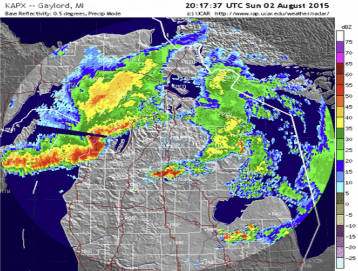
Two of those storms hit basically at the same time, and both went down in northern Michigan history. One made landfall in Leelanau County, bringing 100-mile-per-hour winds that ripped through the Sleeping Bear Dunes National Lakeshore, wreaked mass havoc in the Glen Arbor area, and then continued on to Traverse City. The other hit the east side of the state, hammering West Branch with four-and-a-quarter-inch hail. Combined, they made for arguably the busiest afternoon in the history of the NWS Gaylord office.
“Fortunately, here in the office, we had just ‘sectorized’ shortly before that storm, and what that means is that we had split up northern Michigan, radar-wise, so that one team was focused on the activity moving into Sleeping Bear Dunes and Traverse City, and another team was focused on the storms that were developing over toward West Branch,” Keysor says of the forecasting piece of that puzzle. “Because of that, we were able to get multiple sets of eyes on different parts of the area when all that was developing.”
All told, Keysor and his colleagues issued 28 individual severe weather warnings throughout the northern Michigan region on August 2, 2015.
“Just to put that in perspective, on average, we might only issue 60 or 70 warnings in an entire season summer season most years,” he says. “So, we had about half the normal warnings that we would typically issue in a complete season, and we issued them all in one day.”
The warnings did their jobs: Despite massive devastation throughout the region – out at Sleeping Bear Dunes, for instance, the storm downed approximately 2,000 acres of trees – not a single person was killed in the storm. In fact, 10 years later, the storm has become something of the gold standard for weather forecasting in northern Michigan.
“We’ve saved this storm for radar purposes on some of our training machines, and we've used it for training,” Keysor says. “We’ve run people through this event again, trying to have them make assessments and issue warnings based on what happened. It's been a really good learning tool, because there were just a lot of different parts to that storm that we had to contend with.”
Not that up-and-coming forecasters have to worry about seeing an August 2, 2015 level event regularly, or maybe even ever. Keysor has been at the Gaylord office since 2003, and other than perhaps an October 2007 day “where we had six tornadoes that occurred in northern Michigan throughout the afternoon and evening,” he says he’s never seen anything like what happened 10 years ago today.
“You could work your entire career in northern Michigan as a forecaster, and you might only have one or two days that would even be in the ballpark of that August 2 storm,” he says. “They're that rare.”
No wonder the day continues to live in infamy among northern Michiganders. After-the-fact estimates put the total cost of the August 2, 2015 storm at $82 million – still the costliest severe weather event in local history, though Keysor notes that this year's March ice storm could surpass it when final tallies come in.
And as for those massive hailstones out in West Branch? They’re still the biggest ones ever documented in northern Michigan, with records dating back to 1950.
“Our area seldom even sees hail that’s much over an inch to an inch and a quarter,” Keysor says. “To keep a hailstone aloft in a storm and let it grow over four inches, that requires an amazing amount of rising air within that storm. You talk about a perfect storm? Well, those sorts of things don't come together very often in our area.”
“It's the kind of event that we'll be talking about for many years to come,” Keysor concludes of the August 2015 storm.
Image courtesy of the NWS Gaylord office.
Comment

We Are One People: Indigenous Artists From Across Americas Work Together In Traverse City
Read More >>Looking Back at Northern Michigan’s ‘Perfect Storm,’ 10 Years Later
Read More >>Join Us For a FREE Summer Recess at the Civic Center!
Read More >>TCBN: A New Force In Up North Real Estate
Read More >>


New Elected Probate/Circuit Judge Could be Added in GT County
Read More >>GTB Announces 2 Percent Allocations
Read More >>Peninsula Township Considers Measures from Shutting Down Departments to Selling Off Parkland in Response to Lawsuit Damages
Read More >>Bond Increased to $1M for Walmart Suspect; Competency Exam Ordered
Read More >>While You Were Sleeping: Munson Surgery Team Achieves Historic 'Single-Anesthetic' Lung Cancer Biopsy And Removal
Read More >>Walmart Suspect Arraigned; More Details Emerge on Background
Read More >>