Cedar Run, LaFranier Roads Targeted for Safety Improvements
By Beth Milligan | Sept. 8, 2025
Another accident at the intersection of Cedar Run and Gray roads last week highlighted the recurring dangers of that corridor, which has seen dozens of accidents in recent years and received an “F” rating in a recent safety audit due to its risk of frequent, severe crashes. The Grand Traverse County Road Commission is preparing to take several steps to address safety issues in the corridor. Meanwhile, another road that has seen growing concerns due to increased development and traffic – LaFranier Road – is slated for a speed study that could potentially lower the limit from its current 55 miles per hour.
Cedar Run Road
A state-funded safety study was recently completed for a one-mile stretch of Cedar Run Road from Gray Road to Harris Road, flagging numerous corridor issues contributing to dangerous conditions. Thirty-five crashes occurred in that stretch from 2018 to 2022, a trend rate that has continued through 2025 – with another accident occurring at Cedar Run/Gray just last week. The speed limit is 55 miles per hour in the corridor.
The safety audit, completed by Cincar Consulting Group (C2G) for the Grand Traverse County Road Commission (GTCRC), involved analyzing traffic and crash data and completing in-person field observations of Cedar Run Road at different times of day in May. C2G flagged four key safety issues on Cedar Run Road: intersections, road geometry, young/elderly drivers, and systemic/environmental conditions.
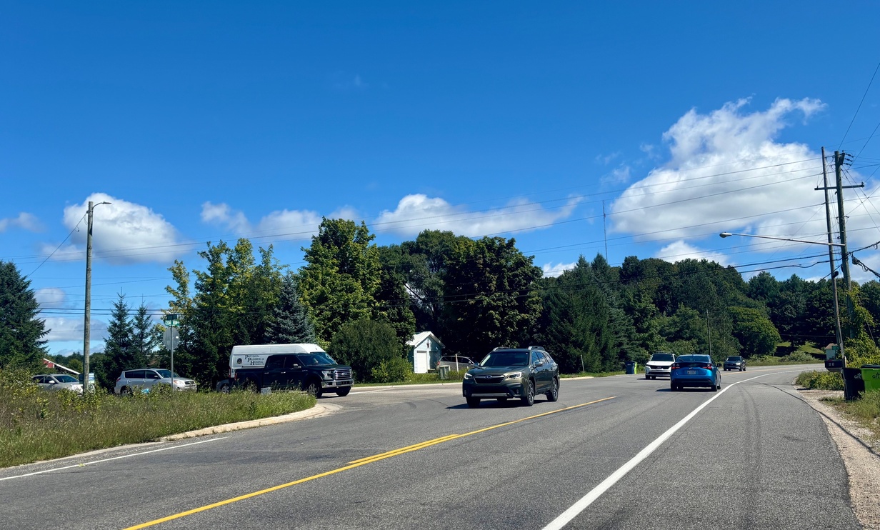
Intersections – particularly Gray (pictured) and Harris but also Gallagher – were the biggest concern, earning an “F” risk rating for frequent, severe crashes. In addition to all three intersections seeing “significant backup and delay” issues during peak commuting and school hours, the Gray and Harris intersections both have sight line challenges. “The combined factors of heavy traffic, backups and delays, and low sight distance means drivers attempting to turn onto Cedar Run Road struggle to find a comfortable time to turn or to have an adequate gap in traffic to safely do so,” the audit states. “This causes drivers to ‘take a chance’ and make risky turns onto Cedar Run Road, often causing angle/head-on left turn crashes or rear-end crashes once the turn is complete and the vehicle is not up to speed.”
Additionally, a lack of proper turn lanes and tapers “furthers the risk of other crashes,” the audit continues. “On a high-speed rural road, it is even more imperative for drivers to have a safe way to turn at intersections.” C2G recommended conducting an intersection study to determine if traffic signals, roundabouts, four-way stops, or other upgrades – such as new turn lanes or tapers – are warranted at each of the intersections. High-friction surface treatment could also be applied to intersection pavement to help drivers maintain better control in bad weather, the audit states.
The geometry of Cedar Run Road – “a winding road with many horizontal and vertical curves” – could also be addressed by clearing trees to improve sight lines and addressing grading/curves, the audit notes. Flattening the crest curve at Harris Road would improve visibility of Cedar Run Road from the intersection, for example, allowing drivers to “better predict oncoming traffic and make safer decisions on when to turn.”
A significant population of young and elderly drivers is another concern. From 2018 to 2022, 60 percent of crashes (excluding animal-related) involved either one or both of those populations. Gallagher Road serves as an access point to TC West Senior High, resulting in a “higher volume of young drivers” coming through the corridor. Meanwhile, older drivers likely struggle with the low sight distance at intersections, the audit states. Educational campaigns and oversize signage – which can help older drivers with poorer eyesight – can be effective in reaching those demographics, the audit states.
System/environmental conditions – the final safety issue flagged – include weather impacts, faded pavement markings, inconsistent signage, and poor visibility of existing signage. At GTCRC’s most recent board meeting, road commissioners flagged some of those improvements as low-hanging fruit they could immediately tackle. GTCRC Manager Dan Watkins said staff have already worked on clearing vegetation within the agency’s right of way and partnered with Garfield Township on replacing burned-out bulbs in road lights. Watkins is expected to bring a cost proposal to GTCRC’s September meeting to upgrade signage in the corridor. GTCRC engineering staff plan to explore grading options along Cedar Run Road.
Road commissioners are also expected to review options for an intersection study, which would likely be completed next May – after Grandview Parkway construction is finished – and provide the traffic warrants/turning volume counts needed for GTCRC to make any significant intersection changes. Road commissioners discussed how well a temporary traffic signal at Cedar Run/Gray installed when M-72 was closed earlier this year for utility work appeared to function – and lamented its loss. Staff noted that the Michigan Department of Transportation only supported the signal being in place during the total closure of M-72 but not the rest of construction, since M-72 remains partially open and Cedar Run/Gray is not an official detour route. Still, its use illustrated how intersection changes might successfully function in the future, road commissioners agreed.
Challenges on Cedar Run Road have been exacerbated by surrounding development and growth even without considering the impact of Grandview Parkway construction, said Road Commissioner Alisa Korn. “I don’t think there’s any denying this is a major corridor for commuters, and there’s just more and more new housing…I think it’s just going to get worse every year,” she said, adding those conditions mean GTCRC needs to “be more proactive” in addressing the corridor.
LaFranier Road
The impacts of development and residential growth on local roads also came up at a recent Garfield Township meeting, where trustees voted to approve a resolution requesting GTCRC and the Michigan State Police to conduct a traffic, engineering, and speed study on LaFranier Road from South Airport Road to Hammond Road. The current speed limit is 55 miles per hour.
As a condition of approval of BATA’s new transit center at the corner of LaFranier/Hammond, BATA is supposed to install a crosswalk from the facility over to the Ridge45 apartment complex. However, BATA Interim Executive Director Chris Davis told trustees that vehicle speeds on LaFranier “dramatically increase the likelihood and severity of crashes involving pedestrians,” adding that it could be more dangerous to have uncontrolled marked crosswalks in such a high-speed corridor than no crosswalks at all. With up to 85 buses running from 5am to 11pm and 146 employees at BATA – along with hundreds of surrounding residents in apartment and mobile home neighborhoods and the planned expansion of Grand Traverse County’s LaFranier Road complex – Davis said improving pedestrian safety is a top priority.
Garfield Township’s resolution follows state law requiring cooperation with the GTCRC and Michigan State Police to undertake a speed study, which will determine the appropriate speed limit for the corridor. Township Supervisor Joe McManus said he couldn’t believe LaFranier Road was still 55 miles per hour given all the development that’s happened in the area. “Hopefully this study…gives that serious consideration, because I would personally fully support reducing that (speed) through there,” he said.
Comment
Road Commission Talks Future of Cedar Run/Gray, Long Lake/Strait, Three Mile/Potter, Franke
Read More >>Free Estate Planning Offered To Veterans
Read More >>Generations Ahead Looking For New Director
Read More >>NoBo Market to Close
Read More >>


First Performer Confirmed For 2026 Interlochen Arts Festival
Read More >>J&S Ends 87-Year Run Downtown; Indoor Sports Complex Opening in TC; More Business Updates
Read More >>Traverse City Repair Café Event Scheduled For This Weekend
Read More >>Garfield Township to Talk Housing PILOTs
Read More >>Join Us For a Special FRIDAY Recess November 7 at TC Curling Club!
Read More >>Spooky Happenings In And Around TC
Read More >>