"Stakes In The Ground": The Boardman Lake Loop And Beyond At TART
By Craig Manning | Aug. 8, 2021
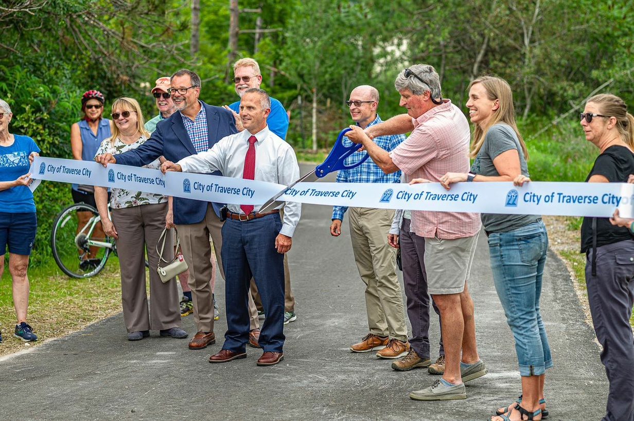
Thirty years: That’s how long the vision of a trail loop around Boardman Lake has been in the works. Now a finish line is in sight. Fresh off a ribbon cutting (above) for a new stretch from Fourteenth Street to the Northwestern Michigan College (NMC) University Center, TART Trails is ready to commence work on the final leg of the Boardman Lake Loop Trail, set to stretch from the University Center to Medalie Park at Logan’s Landing. The Ticker sat down TART Executive Director Julie Clark to discuss the long journey, lessons learned, and what's next for TART.
Ticker: Where do things stand with the final phase of the Boardman Lake Loop Trail?
Clark: Construction will begin any day! There are stakes in the ground where they're marking the centerline of the trail as it goes behind NMC’s campus, and they should be driving piles into the cove soon in preparation for the boardwalk. We’ll have a lot of activity this summer and fall on the next leg, which should be complete by July 2022.
Ticker: Why did this project take so long?
Clark: There were multiple funding sources involved: brownfield funding, Transportation Alternative Program (TAP) funding, DNR Trust Fund money, and private funds. Most of the public funding was designated for particular sections or amenities on the trail, which was challenging from an administration lens.
The two really tricky parts, though – and the reason this trail took 30 years to go all the way around the lake – were the difficulty of construction along that rail line and the cove crossing [leading to Logan’s Landing]. We had to make sure we were in alignment with MDOT Rail’s vision for that corridor, and that includes things you don't necessarily think about like the type of rock you’re using or the width of a drainage channel. And then the cove crossing introduced a lot of complexities, as there always are when you’re building over water.
Ticker: What about environmental challenges, like taking down trees or dealing with animal populations?
Clark: One reason I'm super proud of this project is because [the environmental piece] was something we started with. When we began design and went out to the community to listen to stakeholders, we had the DNR, the Watershed Center, the Grand Traverse Conservation District, and the Grand Traverse Regional Land Conservancy all engaged directly in the project from beginning.
Those stakeholders worked with us the whole way and helped us make sure that we were adhering to environmental values. As the design process got difficult, and as construction prices went up because of the pandemic, there were opportunities to change the project, but we always kept coming back to the values that had been articulated early on: protection of the natural resources; preservation of some of those viewsheds; and limiting tree removal. The path for this trail, for instance, was chosen because it had the least tree removal.
Ticker: The land along this stretch is a mix of public and private land, some owned by NMC. How challenging was it navigating between different landowners and figuring out all the easements?
Clark: That was what took so long. In the beginning, you move at the pace of your partners. And if your partners are landowners being asked to donate easements – and every landowner [along this trail] did donate these easements – you’re going to make sure you respect their time and their process. And that's what we did. This next leg of the trail, between Fourteenth Street and Medalie Park, it’s mostly made up of easements – whether from NMC, right-of-entry on the rail, or private easements from the folks at Logan's Landing.
These were really important partners who also had a say in what the trail would look like. We want the trail to be loved, and that means it has to fit into the environment it's going through. That was all a challenge, and we couldn't even begin those easement discussions until design work was well underway. So that's a lesson learned for us, to make sure we have our landowners engaged early and often.
Ticker: With this next leg completed, there will be a full trail loop around Boardman Lake. What does that add for TART and for the community?
Clark: For many years, it wasn't a happy thought when you thought of Boardman Lake. But through decades, the work that's been done on cleaning up the surrounding areas and bringing this lake back to life, that’s created an opportunity to showcase the natural features of our community.
And loop trails, there’s something special about them, where it feels really good not to have to trudge back the way you came. It’s a pretty short loop: about five miles if you do everything, but the inner circle is a four-mile loop…And since it's nestled right in the middle of the city – accessible from neighborhoods, from businesses, and right on a regional trail – we think use is going to be really high.
Ticker: What’s the status of the trail ‘spur’ that was planned toward Cass and the BATA Headquarters? With BATA planning to move to a new location and close that spot on Cass and South Airport, is TART still planning to add that piece?
Clark: That's on hold. Once BATA [announced the move], and given how COVID changed things, we wanted to make sure the funding and the focus stayed on finishing the loop. Garfield Township does have a nonmotorized plan that calls for improved connections down to Cass and South Airport. So we are working with the Road Commission on long-range future plans to put in an underpass at South Airport Road. Then we can utilize the rail corridor over there, as you get south of South Airport, as a trail extension, to connect to all those businesses along Cass Road. We also see it as an opportunity to eventually keep continuing south, all the way to Chums Corner and out to Interlochen.
Ticker: What did TART learn from this project that you can take away and put toward future projects?
Clark: Something we talk about often at TART is trying to get the pieces in place so that we're ready when opportunities come our way. With Boardman Lake, one of the pieces we really wanted to work on was the landowner collaboration piece. As we are building trails, we know the ‘easy’ ones – the trails along those old rail lines – are done now. The rail heading to Chums Corner is really the last rail line in our area that's even a possibility [for a trail]. The rest, we either have trails along them or they're private and they’ve been turned into other uses. So now we’re putting the puzzle pieces together for working with private landowners and public land – whether it's natural areas, or parks, or conservancy areas – and spending the time that's needed there to get those ideas going.
When we look at our network, we envision another 100 miles on the ground in the next 20 years. And we don't want to wait as long between the start and finish of our projects as we did with [Boardman Lake]. We’d like to see that pace increase.
To do that, a couple things need to happen. There needs to be investment and support at the community level. And that's really not a problem. Right now, people are clamoring for more places and connections to be made, for a lot of reasons: for health reasons, for environmental reasons, for getting around. I'm a one-car family myself, so being able to safely get my kids where they need to go on the trails [is the dream]. I think about West Senior High and all that area out there, and I think about [Garfield Township Supervisor] Chuck Korn’s vision of connecting all the schools and parks and shopping centers by trails, so that people have options.
So I think our vision of another 100 miles can happen. We can't get everything done at once, but we want to build meaningful pieces that make great connections to people and places. So we’re concentrating on communities that are ready to engage, and we’re working with landowners early and often. Those are going to be two key focus areas for us.
Ticker: Which projects are in the immediate future?
Clark: We should have a groundbreaking soon for the Acme Connector part of the Nakwema Trailway, between Bunker Hill and Meijer and then the M-72/US-31 intersection. Another area of focus is Elk Rapids to Maple Bay; putting that trail on the ground is a top priority. We are about to begin engineering on the Sleeping Bear Heritage Trail between Good Harbor Trail, at the northern end of the park, to where the trail ends today, at 669. And then the Three Mile Trail: That's a great example of a community that came to us and was ready, and opportunities that weren't there two years ago are there now.

Community Group Aims To Raise Thousands For Central Grade HVAC
Read More >>Flapjack & Flannel Festival Off for 2026, Will Return in 2027
Read More >>Garfield Township Tees Up Data Center Moratorium; Incomplete Application Submitted for Project
Read More >>Two Proposals Emerge for City West End Property
Read More >>


Peninsula Homeowners vs. Consumers Energy: Long-Running Dispute Heads To MPSC Hearing
Read More >>City Commissioners Approve Two-Way Streets, TIF Ballot Language
Read More >>Buell Retiring at GTACS, Milliman Named Next Leader
Read More >>City Hires Company to Operate Hickory Hills, Aims to Grow Revenue & Programming
Read More >>DDA Talks Next Steps for Riverwalk, Market Pavilion, Rotary Square
Read More >>GTRLC Announces Deal to Permanently Protect YMCA Camp Hayo-Went-Ha
Read More >>